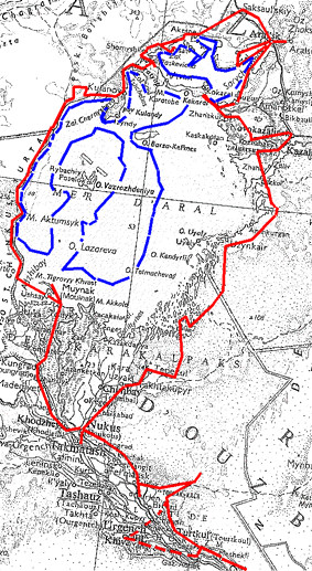
This field trip was the third of a series of missions in the Pri-Aral region. The first, sponsored by the french embassy in Uzbekistan, studied the Ust Urt plateau in may 1997, especially looking for archaeological remains ; the second in august-september 1997, with the participation of a team of the Samarkand Academy of Science and the French Embassy, studied the present state of the Kzyl Kum desert, with Prof. M. Mainguet, from the University of Rheims ( France) and this author. We studied , from Tashkent to Muynak, several transects of the desert within the limits of Uzbekistan, studying water problems and soil degradation . The present expedition was prepared by R. Cagnat, of the French Embassy, ethnographer, who prepared also the may 1997 expedition, P. Chuvin, Director of the french Institute for Central Asia Studies (IFEAC) in Tashkent, and this author. The program was to follow as near as possible the ancient and present shores of the Aral Sea and make observations of various types (ecological, hydrological, ethnological and economical) on the evolution of the region. The participation of Prof. V. Yagodine, from the Ac. of Sciences in Noukous had to be postponed as early as Muynak due to a failure of his lorry, and the rest of the expedition, with V.Korgaev as invited geologist from Taschkent to Nukus, started from Tashkent on April 30 1998. It visited the Golodnaya stepa, the Nuratau mountains, the Aidarkul lake ( the level of which was the highest observed these past years due to heavy precipitations in the Syr Darya catchment area), crossed the south Kzyl Kum from Nurata to the Tyu Ya Muyun dam on the Amu Darya river, part of the Khoerezm district, the Turtkul-Bosten irrigated area with its old earthen fortresses, and the south-west of the Sultan Uiz Dag area , the northern side of which had been investigated the previous year.. Two Toyota Landcruiser cars were used for the complete trip round the Aral Sea. The observations completed those made during the previous year trip. Discussions were held in Nukus with the President of the Karakalpak Ac. of Sciences, relative to the present state of this autonomous republic,as concern water and health problems. The main problem is always the quality of drinking water, as the pipeline tapping the Amu Darya at Tyu Ya Muyun and feeding the region up to Nukus, Kungrad and Tshimba, which is under completion, already carries too much dissolved salts. Rehabilitation of the Amu Darya water quality should be obtained by the construction of two lateral drainage collectors along this river : the total price of this project is estimated at 25 billion US$.
Great changes occur presently in the management of irrigated land of the Amu Darya delta where cotton seems to be systematically replaced by potato, rice and alfafa fields, which tolerate higher salt contents of water than cotton.
We visited the archaeologiacal excavations in Kinderli and went to Kungrad then Muynak. The lower delta is mostly entirely gypsified, many villages are abandoned, and the industrial activity of Kungrad is very low. Small patches of vegetation and trees survive along the abandoned irrigations canals. Most of the irrigation water is directed towards the eastern part of the delta (Takhtakupir), which will be discussed later. We visited the biological station of Muynak, built on a canal south of the town ( salinity 17 g/l) , which is presently inactive , then the fish-canning plant. Previous information said that this installation was not running anymore. This is not the case, although its activity is low. The production which was 17 millions cans before 1960 was 1.5 million in 1996, 2 million in 1997 and should be 2 million in 1998 ( 650 000 produced at the end of april). Machines and installations are mostly obsolete and people work in very difficult and antihygienic conditions. Half of the fish comes from nearby lakes (polluted), the other half is carried from the Caspian city of Turkmenbashi in Turkmenistan by lorries through the Karakum desert. We had also an interview with the director of the hospital, who gave us rather optimistic statistics ( the same as published by WHO) ; anyway he told us that the death rate of young children was 7 per mil which seems disputable. Cancer occurrence is 103 per 100000 ; he told us that no case for typhus appeared for five years, but that B hepatitis cases were twice those observed last year and tuberculosis was rising by 142%, due to poor life conditions. He said that the poor quality of drinking water remains the main problem . We visited a part of the hospital, rather clean but the equipment of which, provided by various agencies, remains very summary ; however it has several brand new ambulances. The hospital covers a total population of 28500 (44 000 in 1951). We saw few patients, mostly children and youg females ; this may be due to the fact that the food is no more free now in the Karakalpak hospitals. There is yet no drinkable water in Muynak, and all the food is carried from the Nukus region, except fish.
All the population of russian origin is gone. Muynak is the basis of oil research teams working on the Vozrojdenie previous island ( now a peninsula, but not yet attainable by car) using helicopters for their logistics.
We then crossed the small villages of Tokmak and the previous port of Ushuay , mostly abandoned by the population and went through the emersed Adshubai bay, now completely covered with vegetation, saxauls near the past shore and ,further , thickets of various species and reeds, with important traces of land fires. A great part of this vegetal cover is dying or dead, due to the constant lowering of the water table. We reached the western cliff ( the Tchink) at cape Yulkentyumsik where is beginning the exploitation of a new gas field, alredy visited last year ; a feeder going south is under construction.. Then we followed the extreme edge of the Tchink , made of samartian white limestones on samartian clays and sandstones, with the spectacular landscape of enormous landslides of variegated rocks well studied by soviet geologists. All this region was forbidden to civil presence up to a recent date. We were able, using tracks carved in the cliff by the soviet army, to reach the present shore , which is on the mean only one km from the 1960 shore. At cape Aktiumisk the various stages of the Aral regression, together with ancient terrasses at a higher level than the 1960 one, were studied. Water samples were taken for analysis. The beach at this place is muddy, with mounds of Cardium shells, scattered with mummified soles, traces of birds, wolves, boars and saiga antelopes. The salinity of water was higher than 65% and temperature 15шC.. At Cape Dyouana there is a sand beach and the remains of a small port built by the army for servicing the previous bacteriological and chemical warfare center of Vozrojdenyie island, with destroyed buildings and electric poles. An ancient massagete wall structure , likely a ring fence for herds, was discovered by P. Chuvin. Massagete tombs were frequently observed all along the Tchink.
All this part of the Yust Yurt plateau, between the edge a of the cliff and the S-N gas feeder followed by an electric line and radio repeaters masts is crowded with remnants of an important past military activity : shells craters, scrap iron of every sort, and curious structures which, on a preliminary analysis, seem due to underground explosions. Our geologist thinks that part of the freshest cliff collapses may be attributed to the shock wave of important underground explosions. This has to be further investigated.
The plateau steppe, almost horizontal, was very green, with numerous herds of saiga. There is no frontier mark with Kazakhstan. At point 209, we found the wreck of an Antonov 24 aircraft, and , a little further, had the surprise to find in the bottom of a ravine going down the cliff to the sea a firn remnant showing the importance of last winter precipitations on all the area. From here on navigation relied on GPS.
Further north, the Tchink lowers and present smoother slopes when the shore bends towards north-east. We found a small intermittent river flowing in a broad grassy valley just before cape Kyumsyuat, where exists an abandoned airtrip along with a past holiday resort on the previous shore ( the sea is about 3 to 5 km away), kept by a single man, the first person we met for more than 350 km. Vozrojdenyie peninsula could be seen on the horizon during all this leg of of our trip, and the northern strait between the peninsula and the northern coast of Aral, is now a few km wide only. Cliffs begin again from this place, lower and smoother than the Tchink, with a large littoral flat covered with bushes , solontchaks and unpassable takyrs. The head of Tchernisheva gulf consists of a gypsum flat with bushes and sand full of dead Cardium, separated from the present seashore by a sand spur. The hinterland consists of low hills covered with steppe, rich in grass at this time of the year, with gullies descending to the previous shores. Just before we arrived at the village of Kulandy, we crossed the southern termination of the Great Barsuky Sands, and found a small deep blue lake fed by an artesian brackish well with a magnificent herd of horses... and the first Kazhar inhabitants. The village, about 300 inhabitants, is not invaded by dunes ; it has an artesian well with slightly brackish water ( 5-6 g/l, temp. 19.2шC) for camels and sheep, the breeding of which is , with horses and a few cows, the only economical activity of the local sovkhoz. There is a small mosquee , a new power line (built two years ago) and a small TV re-emitter. Drinking water is carried every week from the village of Bosoi, some 90 km NW on the now useless gas feeder . People said they had no real problems. There is no more fishers as fish has completely disappeared.
From this place on we followed the old sandy shores with dunes and small residual solontchaks to the head of Tchebas Gulf where we found some ship wrecks ; then we made our way east to the Karatyun peninsula through the seaside steppe , with high grass, many rivulets ans small ponds with a rich bird fauna. We crosssed the peninsula where we found a small hamlet of khazar shepherds along a running stream ( Jidelisai), and, arrived on the Small Sea shore. Due to very poor meteorological conditions, we dispensed from going to visit the hamlet of Aidast, on the previous straits between Kokaral island, and crossed the large steppe between the sea and the samartian plateau on the north. We tried to follow the new beach, which was impassable due to marshes and instable takyrs. A long trip in the undulated steppe, with small cliffs of various tertiary variegated rocks lead us to the village of Agespe which we were able to reach only through compass and GPS navigation . A few km north exists an intersting khazar cimetery with a four tower mausoleum made of red ferruginous sandstone. The village is located at the head of Perowsky bay, in a valley with quaternary fluviatile sediments, at the place where the Small Barsuki sandfield coming from the north and dammed by the eastern tertiary hills reaches the sea ; and dunes have invaded a big part of the village, which has 30 inhabited houses with 200 inhabitants ( half the previous population), of which 45-50 are children, with a small school. The hamlet has a modern power line coming from the north, a TV reemitter and an artesian well, dug down to 1000 m in 1995 with the US aid and which gives excellent water. The auxiliary doctor in Agespe, M. Y. Dunes, who formerly was medical orderly in the soviet navy in Vladivostok, gave us some medical statistics : for 5 years the births are between 5 to 19 children, ( 3 in the past) eight out of ten survive after one year. There are no more problems with water but many people, especially older ones, die from diseases linked with inhalation of salt dust carried by the wind. He himself lost recently two daughters, aged 19 and 25. The population essentially lives on meat of their herds. A few fishers survive and catch soles from the gulf, the level of water having rised last year by 30 cm ( see further). M. Dunes said that the principal needs today for his village is a car for his rounds of visits, money for medicines, better furniture of electricity and help to control the progression of sand dunes.
Crossing the head of the gulf invaded by dunes, we took him north to the town of Saksaulskii ( 20 000 inhabitants), a station on the main transaralian railway, the activity of which is very important. Saksaulskii is about 60 km NE of Agespe at bird eye, through a very poor trail. Entirely devoted to the traffic and repairs of rolling stock, this city is one of the most miserable towns we were able to visit, with streets invaded by garbage etc., and veiled by the fumes of the railway workshop. Pretty russian houses have been abandoned by their inhabitants, and replaced here too by Kazars nomads. The population seemed hostile to our short visit.
The plain around is a treeless desert for kilometers ( no more saxauls...), surrounded by cliffs on the north and west with big solontchaks at their foot. Farther from the town, the steppe is again covered with vegetation , bushes, saxauls, graminacean tulips etc, and birds, rodents, insects... and snakes. Many temporary pools were observed, some being already transformed into solontchaks.
We then arrived at the town of Aralsk by the main road from Aktiubinsk. The contrast with Saksaulskii was evident, as Aralsk is a clean town following the local standards, clean streets with trees along and in small gardens people take great care of, although water is very rare, sparsely distributed and brackish. The previous dried port always possesses his rotten cranes, and some shipwrecks subsist in the basins where puddles remain and in the dessicated gulf,. We were welcomed by the mayor, M. Baimirzaev, elected two years ago and a previous engineer in petroleum industry. He explained to us his effort to keep the city living and in as good condition as possible. The population in Aralsk which was formerly 50 000 fell down to 28000 and is slightly increasing now. The mayor has great hopes for the future due to beginning oil and gas prospection in the area.
The great achievement of M. Baimirzaev has been the construction of the dyke damming the Berg strait between previous Kokaral island and the estuary of the Syr Darya river. Following a previous unavailing attempt in year 1992 to prevent water from this river to be loosed and divert it to the Small Aral Sea, the Mayor was able to build a 16 km dam at the same place, which resisted the tempests of the Small Sea during 1997-1998 winter. We first visited the left shore of the previous Sary Tchaganak (Aralsk ) gulf down to the Koktirnak peninsula, following previous shores covered with reeds. A small residual bay linked to the Small Sea exists, and is surrounded by flats, partly covered with tamaris and artemisia bushes, solonchaks with permanent small salt tornadoes, and fringed with reeds . Then we visited the eastern sea shore, again with bushes and solontchaks and some old wrecks, a small fisher camp where we could see the Small Sea fish catches, soles (kembala), and two other big fishes, kiroun and boblia. Going south, where the Jilandi sands cover the area with dunes, the vegetation of which was remarkable for its density, we reached the villages of Karatiun, Bugun and Karashalan, dedicated to camel and horse breeding, and seemingly in rather good condition. We crossed the two arms of the Syr river on boat bridges - the discharge being at this time 180 cubic meters per second, before we reached the dam after crossing the delta marshes and a part of the emersed Great Sea.
The dam is an arcuate sand dyke, convex to the south. Sand is taken from its south side by scrapers, and the dyke does not contain any rocky material, contrary to some previous informations. The width at the bottom is about 100 meters, 10-15 m at the top, with a height going from one meter near the previous shores to about 10 meter in the center of the strait ( 8 km of the shores), where the remnants of the previous Berg canal, dug in the 80's for the passage of boats from the Small Sea to the Big Sea can yet be seen. On the Small Sea side, the top above the level of water is about 2.5 to 3 meters. At the middle of the dyke, waves have badly eroded the dyke and built a small beach 1 or 2 meter wide. The problem is presently to reinforce this part of the dam by heaping up and tamping sand . Two dumpers and three bulldozers were presently working there. A large quantity of earth-working machines was still. The mayor explained us that the works had been carried on with the rayon ( district) money with strictly no help from the government, that reinforcing the dam with rocks taken from the nearby cliff of Kokaral was necessary but presently too expensive, and that the lack of spare parts for the machines explains the small activity on the working site. " We do not need more experts, we do not need really money, we need new excavators and bulldozers ", he said.
The result is, as said above, that in one year the level of the Small Sea shifted 30 cm in the first year and presently one mm a day. The salinity of the remaining Small Sea fell from 35 g per liter to 20-21 g, and fish has been reintroduced and seems to live well. On the dried and recently re-submersed areas, a new vegetation is growing, with lots of birds. There is hope that fishing can really start again ; a secondary effect is the extinction of salt tornadoes on the dry shores.
Simple considerations on the water and salt balance show that the new Small Sea system is instable, and the mayor told us that in order to keep the salinity at its present level he intends to reopen a small controlled strait at the western end of Kokaral island, to prevent the accumulation of salt in the basin. " We hope that the input of water from the Syr Darya, even if it is drainage water, will not decrease but on the contrary increase. We shall take care of the rest ", the mayor concluded.
It is most unfortunate that this remarkable achievement is not supported by authorities, national or international, since it represents, apart from its symbolic significance, the most effective way to preserve part of the previous Aral Sea. It seems that uzbek authorities, who possesses the southern part of the previous Aral Sea, have different ideas and prefer to develop artificial lakes in the Amu Darya delta rather than to convey drainage water in the western and deeper part of the Big Sea west of the Tchink, which will be entirely closed in a few years.
From the dam, we went to Novo Kazalinsk, crossing the villages of Janakourilsk and Oktabriask, through the western reaches of the delta. A great part of the canals are abandoned, ground is covered with gypsum and very few fields are yet cultivated, except in the immediate surroundings of villages. Numerous installations are uncompleted, as are also quarters for peasants. There is misery everywhere. All wells are brakish. There is no distribution of drinking water, except in bottles. Children look in bad health. We were told that Unicef did a lot of work to remedy this dramatic situation, but we had not the occasion to discuss with medical authorities in this area.
After crossing again the Syr Darya on another boat-bridge, we arrived at Novo Kazalinsk, which has lost a good part of its previous population . Buildings are in a very poor state and most of the people live in cob dwellings. There is no drinkable water, and distribution rationed, as it was in Aralsk. There are yet factories working around the railway, trafic being the main activity of the town now. Here we met a young Dutchman cycling from Moscow to China, who asked us information on the road to Tashkent, which we were able to give. From Novo Kazalinsk we went to Kazalinsk and recorded that most of the trees along the roads and the canals had been cut, for winter heating. Here is one of the big problems - with water quality- of the whole area. We were said in Aralsk and Kazalinsk that due to lack of funds, there was not enough gas coming from Uzbekistan to feed 1- the power sations, hence the frequent cuts ;2- the collective heating system of towns ; and temperature fell down to -38шC this last winter in the North East of Aral...To the question : why coal from Kazakhstan mines cannot be used, it was answered that installations, either for power or heating were not adapted to coal, and that no effort had been made in this respect.
We met again the muddy Syr Darya flowing between steep silt collapsing banks and crossed the south western part of the delta, as naked as the western part, with few villages apart in the gypsum plain, trees along abandonned canals, half-destroyed bridges.There was practically no traffic on the main pebble road which crossed some seconary branches of the river at Kojabaki, Boskol and Kommunism, where we took a guide for some km. We crossed a series of great ponds created on the bottom of the previous Boskol gulf of the Aral Sea, fed by canals following the bed from the Kyuan Darya, one of the ancient southern branches of the Syr, with brackhish water running. Dead carps floated on the water. The vegetation around the lakes was thick with many birds, especially ducks. We arrived in the last hamlet where begin the first dunes of Kyzyl Kum - dunes with vegetation showing numerous signs of sand reactivation. The village is named Saraman and is partly buried in sand ( 45ш11'N, 61ш53'E). A few km east we visited an isolated minaret completely restored, the Saraman Koзa, about 12 m high and said to be built in the IXth-Xth century ( hill 67 of the 500000th map, Kazalinsk). We were said to follow from there the electric line to the south and dsicovered that this line was entirely destroyed after a few km. Navigation had to be done further with GPS. Dunes were now predominant, always with a thick cover of bushes and fresh grass and some traces of reactivation. Temperature in early morning went under 0шC. We found further artesian wells with slightly brackish wter from the Creaceous beds, creating small ponds, then a small settlement in a nude plain called Ajjar ( 44ш46N, 61ш38' E, not on the 1977 map), along a small pond ; people did not speak russian, but a lorry driver coming from Uzbekistan told us to follow back his own traces. Finally we saw that the destryed power line went on to a settlement name Kyzyl Kum, announced by a tomb on a dune . Here we found a small village entirely destroyed to the ground, with a partly abandoned meteorological station ( 44ш32, 61ш24). The keeper and his aid lived here with their family, and they were yet working, mesuring and radioing their data everyday. Part of the basic equipment, although obsolete, was in order. These people had an artesian well ( 5-7 g/l, 25шC) with slightly brackish water, and a small thicket of trees and a garden. They said they received food and goods every six months, and lived from hunt, their own cattle and vegetables production. They said they had no problems with health, and that one or two lorries a day follow the trail from may to december, none during winter. Temperature fell down to -30шC this winter. They said also that the previous population ( 300 persons) had left and destroyed the village in 1995. They did not explain the destruction of the electric line. Close inspection of the destroyed village has shown that concrete poles once made a fence around the village, which could be a previous " worker camp " reported on the east coast of the Aral sea.
As the weather had been rainy the previous days, we did not try to visit the present eastern shore which was more than 100 km away from our position, and which was completely unknown to our interlocutors, even the custom officers. Therefore we tried to follow the meridian 61шE, between the dunes which became higher and higher as we went on to the south, always coverd with vegetation, and the valleys between filled by solonchaks or mud puddles, always with reeds and their bird fauna. We arrived at the fringe of the previous Akpeti archipelago, and we follawed traces of the previous course of branches of the Yana Daryan themselves filled by solonchaks sometimes containing salt water , with shores covered with halite. Sand in the hollows was white, and reddish on the dunes, the limit of water being indicated by the presence or not of numerous shells of Cardium. From here on some of the solonchaks presented the well-known gypsum " cauliflowers " described by geographers in this region. Most were old, but others were growing through halite solonchaks and seem to be due to underground water rising through the salt floor.We saw neither a man or a camel in this region, and only some antelopes were found. The trail sometimes crossed very thick saxaul and tamaris thickets and other trees. This part of the Kyzyl Kum seems to have kept its original natural status. Anyway, it appears that if bushes were vigourous on the dunes, most were dying in the hollows, due to the lowering of the older water table, in relation with the lowering of the sea.
As the weather was becoming more and more rainy, we decided to reach the Beltau hill ridge as soon as possible,. The system of dunes abruptly end on the ancient terminal playa of the Yani Daria and Akcha Darya, a vast subhorizontal plain going west-east from the Takhakupir area to longitude 62шE, with a poor and scanty vegetation and terminal drainage lakes. In the middle of the plain, which is crossed by low ranges of dunes coming from the Beltau massif, we found among well preservated natural dry channels the remnants of a cimetery with a cupola chapel and a minaret ( Kunya Bugut, 43ш08N, 60ш44E) and, a little further on the west, a high tower made of dry stones which could have been a watching tower. Going west we found remnants of unfinished and abandonned irrigation works of the soviet time, and we arrived in the most eastern villages of the Takhtakupir ( " the wood bridge ") area, where the Beltau ridge is no more covered by dunes. At the difference of the terminal deltas of Amu Darya and Syr Darya this region is well cultivated, and seems relatively prosperous ; few fields are abandoned, cotton is replaced by rice, and we saw aircraft pouring chemicals over the fields. Villages and the town of Takhtakupir were cleaner than cities in the Syr Darya delta or the Kungrad area ; and this went on down to Nukus, which we found again after our two weeks circumnavigation of the Aral. No drinking water is locally available, except through some little distillation plants.
As a conclusion, we can say that :